![](/images/other/stat-length.png)
![Trail On foot Losheim am See - Schluchtenpfad - Photo](https://media.geolcdn.com/t/1900/400/ext.pjpeg?maxdim=2&url=https%3A%2F%2Fstatic1.geolcdn.com%2Fsiteimages%2Fupload%2Ffiles%2F1545311037marcheuse_200dpi.jpg)
Schluchtenpfad
SityTrail - itinéraires balisés pédestres
Tous les sentiers balisés d’Europe PRO
![Length](/images/other/stat-length.png)
Length
3.1 km
![Max alt](https://static1.geolcdn.com/siteimages/upload/files/1508320355ic_sort_altitude_max_24dp.png)
Max alt
347 m
![Uphill gradient](https://static1.geolcdn.com/siteimages/upload/files/1508320355ic_sort_den_pos_24dp.png)
Uphill gradient
110 m
![Km-Effort](/images/other/stat-length.png)
Km-Effort
4.7 km
![Min alt](https://static1.geolcdn.com/siteimages/upload/files/1508320355ic_sort_altitude_min_24dp.png)
Min alt
229 m
![Downhill gradient](https://static1.geolcdn.com/siteimages/upload/files/1508320355ic_sort_den_neg_24dp.png)
Downhill gradient
140 m
![Boucle](https://static1.geolcdn.com/siteimages/upload/files/16400158638029165_repeat_loop_refresh_sync_direction_icon.png)
Boucle
No
Signpost
Creation date :
2022-02-11 12:43:53.3
Updated on :
2022-02-11 12:43:53.3
![On foot](https://static1.geolcdn.com/sitytour/trail-icons/100.png)
1h03
Difficulty : Easy
![Scan this QR Code to open this trail in the SityTrail application](https://capi.geolives.com/qq0zvz2zws4bq2lad0pu/sitytour/trails/3087711/qr.png?size=200)
FREE GPS app for hiking
About
Trail On foot of 3.1 km to be discovered at Saarland, Landkreis Merzig-Wadern, Losheim am See. This trail is proposed by SityTrail - itinéraires balisés pédestres.
Description
Symbol: stilisiertes grünes Foto mit weißem schrägem „S“ und Aufschrift „Schluchtenpfad“
Positioning
Country:
Germany
Region :
Saarland
Department/Province :
Landkreis Merzig-Wadern
Municipality :
Losheim am See
Location:
Unknown
Start:(Dec)
Start:(UTM)
337733 ; 5481706 (32U) N.
Comments
Trails nearby
![Trail On foot Wadern - Forsthofrunde - Photo](https://media.geolcdn.com/t/375/260/ext.jpg?maxdim=2&url=https%3A%2F%2Fmedia.geolcdn.com%2Ff%2F84dbe70d-9d61-4cd6-8ea6-dd4f7a31e9fb.jpeg)
![On foot On foot](https://static1.geolcdn.com/sitytour/trail-icons/100.png)
Forsthofrunde
On foot
Easy
Wadern,
Saarland,
Landkreis Merzig-Wadern,
Germany
![](/images/other/stat-length.png)
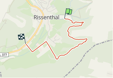
6.4 km | 8.7 km-effort
1h 58min
![](https://static1.geolcdn.com/siteimages/upload/files/16400158638029165_repeat_loop_refresh_sync_direction_icon.png)
Yes
![Trail On foot Wadern - Lücknerweg - Photo](https://media.geolcdn.com/t/375/260/ext.jpg?maxdim=2&url=https%3A%2F%2Fmedia.geolcdn.com%2Ff%2F84dbe70d-9d61-4cd6-8ea6-dd4f7a31e9fb.jpeg)
![On foot On foot](https://static1.geolcdn.com/sitytour/trail-icons/100.png)
Lücknerweg
On foot
Medium
Wadern,
Saarland,
Landkreis Merzig-Wadern,
Germany
![](/images/other/stat-length.png)
16.1 km | 22 km-effort
4h 56min
![](https://static1.geolcdn.com/siteimages/upload/files/16400158638029165_repeat_loop_refresh_sync_direction_icon.png)
No
![Trail On foot Schmelz - Nordic Walking, Strecke 2 mittelschwer - Photo](https://media.geolcdn.com/t/375/260/ext.jpg?maxdim=2&url=https%3A%2F%2Fmedia.geolcdn.com%2Ff%2F7d034ddd-06ce-42c2-ad57-567873ddb090.jpeg)
![On foot On foot](https://static1.geolcdn.com/sitytour/trail-icons/100.png)
Nordic Walking, Strecke 2 mittelschwer
On foot
Easy
Schmelz,
Saarland,
Landkreis Saarlouis,
Germany
![](/images/other/stat-length.png)
5.1 km | 6.1 km-effort
1h 23min
![](https://static1.geolcdn.com/siteimages/upload/files/16400158638029165_repeat_loop_refresh_sync_direction_icon.png)
Yes
![Trail On foot Schmelz - Nordic Walking, Strecke 1 leicht - Photo](https://media.geolcdn.com/t/375/260/ext.jpg?maxdim=2&url=https%3A%2F%2Fmedia.geolcdn.com%2Ff%2F7d034ddd-06ce-42c2-ad57-567873ddb090.jpeg)
![On foot On foot](https://static1.geolcdn.com/sitytour/trail-icons/100.png)
Nordic Walking, Strecke 1 leicht
On foot
Easy
Schmelz,
Saarland,
Landkreis Saarlouis,
Germany
![](/images/other/stat-length.png)
3.7 km | 4.6 km-effort
1h 2min
![](https://static1.geolcdn.com/siteimages/upload/files/16400158638029165_repeat_loop_refresh_sync_direction_icon.png)
Yes
![Trail On foot Losheim am See - Oppig-Grät-Weg - Photo](https://media.geolcdn.com/t/375/260/ext.jpg?maxdim=2&url=https%3A%2F%2Fmedia.geolcdn.com%2Ff%2F8c5067b1-77b3-49a7-9635-b694a9f36ec0.jpeg)
![On foot On foot](https://static1.geolcdn.com/sitytour/trail-icons/100.png)
Oppig-Grät-Weg
On foot
Easy
Losheim am See,
Saarland,
Landkreis Merzig-Wadern,
Germany
![](/images/other/stat-length.png)
11.3 km | 16.3 km-effort
3h 42min
![](https://static1.geolcdn.com/siteimages/upload/files/16400158638029165_repeat_loop_refresh_sync_direction_icon.png)
Yes
![Trail On foot Losheim am See - Kleiner Lücknerweg - Photo](https://media.geolcdn.com/t/375/260/ext.jpg?maxdim=2&url=https%3A%2F%2Fstatic1.geolcdn.com%2Fsiteimages%2Fupload%2Ffiles%2F1545311037marcheuse_200dpi.jpg)
![On foot On foot](https://static1.geolcdn.com/sitytour/trail-icons/100.png)
Kleiner Lücknerweg
On foot
Easy
Losheim am See,
Saarland,
Landkreis Merzig-Wadern,
Germany
![](/images/other/stat-length.png)
8.4 km | 11.1 km-effort
2h 31min
![](https://static1.geolcdn.com/siteimages/upload/files/16400158638029165_repeat_loop_refresh_sync_direction_icon.png)
Yes